Camp Utley was a prominent Civil War Union training camp located in Racine, Wisconsin, during the early 1860s. It served as the organizing and mustering site for several Wisconsin regiments and batteries, including the 4th Wisconsin Infantry and the 22nd Regiment, Wisconsin Infantry.
PRESERVATION – RACINE, INC.
NEWSLETTER
SUMMER 1986
125 Years Ago
Where Was Camp Utley?
In the summer of 1861, during the first weeks of the Civil War, a camp was established in Racine where the Fourth Wisconsin Regiment mustered before it left the state for active service in the Union Army. This place of rendezvous was named “Camp Utley” in honor of William L. Utley, the state senator from Racine who was then acting as Adjutant General for Wisconsin and later became the commanding officer of the Twenty-Second Regiment.
According to Eugene W. Leach, Racine’s most accomplished early historian, the camp was located “south of the city on the lake shore, on the farm of Truman G. Wright, and occupied 75+ acres, extending south from Sixteenth street to the grounds of Racine college—then a little south of the present location of DeKoven avenue—and reaching back one-fourth mile or more west from the lake.” His situation of the camp is roughly correct, but it is misleading. “In attempting to visualize the site of Camp Utley in 1861,” Leach cautioned his readers, “it should be remembered that the bank of the lake was then about 800 to 1,000 feet east of where it is now.” He thought that half or more of the land which was a part of the camp had been washed away by the lake. That is not so.
For the site of the camp Leach relied solely, it seems, on an account printed on June 12, 1861, in the Racine Weekly Advocate which described the grounds as “those adjacent to the college, on the farm of T. G. Wright, Esq. They are finely located on the bank of Lake Michigan, at an elevation of forty or fifty feet and comprise some 75 acres.” He apparently did not see another account printed the same day in the Weekly Journal which commended “the attractive grounds of Truman G. Wright, Esq. … comprising some forty acres of prairie, almost immediately on the bank of Lake Michigan.” While the two reports agree on whose land was used, they differ widely on their estimates of the acreage and they disagree precisely as to whether the camp was “on the bank” or “almost immediately on the bank” of the lake.
Other descriptions—to be found in letters written from Camp Utley by soldiers sojourning there—are equally divided. “Our camp is situated immediately on the Lake shore,” wrote one. Another placed it “on the fair ground near the lake.” A third referred to “the lake lying to the east of the camp”; a fourth set it “on the shore of the lake and in the center of a large grove”; and yet another wrote: “Camp Utley is very pleasantly located almost within a stone’s throw of Lake Michigan.”
The more precise references to the camp indicate that it did not extend to the shoreline of the lake, and the legal descriptions of the lands on which it stood bear that out. In 1861 the farm on which Camp Utley was established was only nominally the land of Truman Wright. Legally, title to the farm was still held by the estate of his brother Charles S. Wright, who had died in 1855. At one time Charles owned all the land from the lake west to the tracks of the Chicago and Northwestern Railroad and north from Twenty-First Street to the north line of Section 21 in the Town of Mount Pleasant. (The north line of the section lies approximately one half block south of Sixteenth Street.) In 1850 Charles platted all of his land lying along the lake east of Main Street as a subdivision called “South Racine” and sold almost all of the lots. Not long after, the bluffs along the lake began to erode seriously. Some of the lots slid down to the shoreline and disappeared. Few of them ever had houses built on them; so Wright’s view of the lake remained unimpaired.
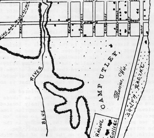
In 1852 Charles donated ten acres in the southeast corner of his remaining land to the Episcopal Diocese of Wisconsin as a site for Racine College. In 1861, therefore, the college comprised only a bit more than a quarter of the lands which the DeKoven Foundation occupies today. They extended only about half way to DeKoven Avenue north from Twenty-First and half way to Grand Avenue west from South Wisconsin (formerly South Main Street). Thus, the “farm of T. G. Wright, Esq.” on which Camp Utley stood included nearly two hundred acres and was bounded on the north by the section line, on the east by Main Street, on the west by the railroad, and on the south by the grounds of Racine College and the present line of Twenty-First Street. The lands immediately along the lake were no longer a part of it. [There is a historical map illustration here labeled “CAMP UTLEY, Racine, Wis. 1861” showing streets, the railroad, the lake, and various landmarks such as the College, Fair Grounds, etc.] This map is a combination put together by Don Rintz of two maps of Racine which date from the late 1850s. The style: “Camp Utley, Racine, Wis.” and the illustration of “Badger Boys On the road to Dixie’s land,” which appears at the address block of this newsletter, come from the letterheads of stationery which could be bought in 1861 at the shop of S. B. Steers, Bookseller, Titus’ Block.
It is possible, therefore, to establish clearly two of the boundary lines of the camp: they were the northerly and easterly boundaries of the Wright farm—on the north, Wisconsin, Pearl (College), Chippewa (Park), Villa, Campbell (Grand), Center, and Racine—the only streets which ran to the city limits at that time—all ended at the fence of the farm. “Where the main entrance to the camp will be we know not,” wrote the Advocate: “at present a gate at the termination of Wisconsin street opens into the grounds.” That gate would have blocked the way where the house at 1632 South Wisconsin now stands. On the east, a fence ran along the west side of Main Street to the grounds of the college. Within the fence was a private race track which became the parade ground for the camp. The tents for the recruits were “placed in military order,” according to the Advocate, “on a ridge parallel with Main street, on the west side of what was the race course.”